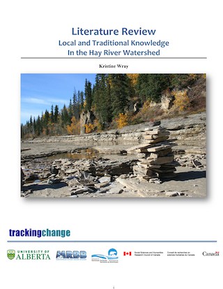
The Hay River
The Hay River Basin plays an important role in the economic, social, and cultural well-being of many Indigenous peoples (Wray, 2019). Due to their reliance and stewardship of the river and its resources, Indigenous peoples have developed valuable knowledge about the “state of the basin that can contribute to our understanding of historic and contemporary issues of planning, management, and monitoring” (Wray, 2019: 3). The Hay River is named for the rich hay fields, which were nourished by the floods sporadically experienced at the river’s mouth (Wray 2016: 3, Piper 2009:261). The Hay River itself, originates in Northeastern British Columbia, flowing east into Alberta, “from there, the river continues to flow east and is joined by its major tributary, the Chinchaga River” (Aboriginal Affairs and Northern Development Canada, 2014:3). The Hay River eventually ends in the west basin of the Great Slave Lake in the Northwest Territories, flowing 702 kilometers and covering an area of about 51,700 kilometers (Aboriginal Affairs and Northern Development Canada, 2014:3)
“The Hay River Basin is mainly situated within the traditional territories of the Dene Tha’ First Nation, Alberta, and British Columbia, the Fort Nelson First Nation in British Columbia, and the Dehcho First Nations, Kátł‘odeeche First Nation, and Northwest Territory Métis Nation in the NWT” (Stantec/Government of the Northwest Territories, 2016: ii). At least six Indigenous groups live in the Hay River Basin including the Woodland Cree, the Sekani, Dane-zaa, Dene Tha’, Dene and Metis. Given their longstanding knowledge of the area, each Indigenous group has its own unique traditions and knowledge associated with the Hay River Basin (Wray, 2016). More specifically, the Hay River Basin “supports the traditional lifestyle of residents from the communities of Enterprise and Hay River as well as the K’atl’odeeche and West Point First Nations in the NWT and in Alberta, the communities of Indian Cabins, Steen River, Meander River, Zama City, Habay, Chateh (Assumption), Rainbow Lake, Hutch Lake, Slavey Creek, and Lutose” (Aboriginal Affairs and Northern Development Canada, 2014:3). The total population of the basin is estimated to be 5,897 (2011 census), the Town of Hay River being the largest.
The Hay River Basin provides necessary habitat for wildlife and aquatic species that are also utilized by Indigenous people for subsistence hunting and fishing. Fish species include lake whitefish, walleye, burbot, northern pike, longnose sucker, inconnu and lake trout” (Stantec/Government of the Northwest Territories, 2016: iii). Traditional knowledge in this region is an invaluable source of holist knowledge that can “contribute to our understanding of historic and contemporary issues of planning, management, and monitoring” (Wray, 2016: 5) There is limited availability of documented sources of traditional ecological knowledge/local ecological knowledge in the Hay River in comparison to other regions.
Quick Facts
- On average, 115,000 litres of water passes by the town of Hay River each second. By comparison, the Slave River has an average annual flow rate of 3.4 million litres each second” http://sdw.enr.gov.nt.ca/nwtdp_upload/THE_HAY_RIVER__WATER_MONITORING_ACTIVITIES_IN_THE_HAY_RIVER_REGION_-_PLAIN_LANGUAGE_REPORT.pdf
- The town of Hay River is known as the “Hub of the North” for “its key role in facilitating the movement of natural resource good and labour, in, out and around the territory” – https://www.northernpublicaffairs.ca/index/life-in-hay-rivers-high-rise/
- “The Hay River Basin provides extensive aquatic habitat values for fish and wildlife, including an estimated 26 fish, 81 bird, 4 amphibian, and 12 aquatic mammal species.
- Species of commercial, recreational, and subsistence interest include lake whitefish, walleye, burbot, northern pike, longnose sucker, white sucker, inconnu, and lake trout.” https://www.enr.gov.nt.ca/sites/enr/files/aquatic_knowledge_hay_river_basin.pdf
Sources:
- Local and Traditional Knowledge In the Hay River Watershed
- Acquatic Knowledge For The Hay River Basin
- Water Monitoring Activities In The Hay Region
Name:
Kátło’dehé is the South Slavey Dene name for the Hay River, or an earlier spelling Xatlo Dehe” or from the K’átł’odeeche First Nation report, K’átł’odee ‘willow grass river,’ referring to the origins of the river in Hay Lakes, northern Alberta, which is a prairie-like area. In Chipewyan, the Hay River is Hátł’oresche. In Cree, it is Maskosï-Sïpiy” (AANDC 2014). The Hay River is named for the abundant hay fields, which were nourished by the floods periodically experienced at the river mouth, which also brings driftwood into the Great Slave Lake (Piper 2009:261).
Size: The basin size is 51, 700 km2 (Wray, 2019: 9), the length is 702 km.
Population: The population of the Town of Hay River is about 3600, the rest of the basin is less than 2 people per square km (Wray, 2019:9).
Jurisdictions: British Columbia, Alberta, Saskatchewan, and the Northwest Territories. The Hay River Basin is considered to have been home to at least six Aboriginal groups: the Sekani, Dane-zaa, Dene Tha’, Dene, Métis, K’átł’odeeche First Nation, and the Woodland Cree (Wray, 2019:3).
Ecology: Streams, mountains, boreal forest, fish and other aquatic life, caribou, arctic animals, arctic ocean, muskeg.
Development: Known as the ‘hub of the north’ – located on major intersections for bus, rail, and air. Significant supply for operations of Mining – Pine point Mine (now closed).
RELATED PUBLICATIONS
- Air Land and Water Planning - Mackenzie Athabasca
- Local and Traditional Knowledge in the Athabasca Watershed
- Uranium Exploration in the Athabasca Basin
- Facts About The Athabasca Basin
- About The Athabasca Basin
- Water Availability In The Athabasca River Basin
FMkFN—Fort McKay First Nation (1994) There is Still Survival out There: A Traditional Land use and Occupancy Study of the Fort Mckay First Nation. Calgary: Arctic Institute of North America
FMkFN-IRC – Fort McKay First Nation – Industry Relations Committee (2008a), Fort McKay First Nation. Traditional Knowledge Report. Parsons Lake Resources Park. Environmental Assessment Report. Calgary: FMA Heritage Resources Consultants Inc.
Quinn, F. (1991). As long as the rivers run: The impacts of corporate water development on Native communities in Canada. Canadian Journal of Native Studies
Co-Investigators
Brenda Parlee
Arn Keeling
Bruno Wichmann
Dave Natcher
Henry Huntington
Herman Michell
Jennifer Fresque-Baxter
Mark Nuttall
Shalene Jobin
Sonia Wesche
Trevor Lantz
Val Napoleon
Master Students
Laura Gaitan
M.A. Candidate, Geography
