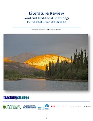
The Peel River
The Peel River sub-basin, named by the Gwitch’in, spans an area of 74,000 square kilometers, “from its headwaters in the Yukon to its confluence with the Mackenzie River near Fort McPherson in the Northwest Territories” (Mackenzie River Basin Board, 2003: 133). The Peel River is approximately 350 kilometers, with major tributaries including the Ogilvie, Blackstone, Hart, Wind, Bonnet Plume, and Snake rivers (Mackenzie River Basin Board, 2003: 133). The majority of the Peel Watershed region is uninhabited, leaving much of the wilderness in untouched condition (Jaremko, 2017: 6). The Peel Watershed is unique in the fact that it is so untouched and underdeveloped. There are, however, some notable landmarks. The first being the Bonnet Plume River: “as a condition of the First Nation of Nacho Nyak Dun Final Agreement, the Bonnet Plume River was designated as a Heritage River under the Canadian Heritage Rivers System, mainly because of its natural beauty and recreational and cultural value (Mackenzie River Basin Board, 2003: 133). Additionally, the Tshuu tr’adaojìich’uu or Tshuu tr’idaodìich’uu canyon is one of the most significant places along the Peel River, with many traditional stories attached to it due to its treacherousness (Gwich’in Social and Cultural Institute, 2016). The untouched abundance of wildlife, water, forest, and other ecology makes it one of the most stunning places in Canada.
Indigenous communities living along the Peel River include the Nacho Nyak Dun First Nation (Mayo), the Tetlit Gwich’in (Fort McPherson), the Tr’odek Hwech’in (Dawson), and the Vuntut Gwitch’in (Old Crow). “The only permanent community in the Peel sub-basin is Fort McPherson, and nearly all inhabitants of the sub-basin live in this community. The population of Fort McPherson was estimated to be 760 in 2001 (Mackenzie River Basin Board, 2003, 133). The Peel River is an important source of culture, tradition, and knowledge to peoples in the region. “The water, wildlife, and fisheries resources produced in the Peel Basin are used to support the traditional culture and subsistence lifestyle (hunting, trapping, and fishing) of numerous residents within the area” (Water Quality Review, 1999: 1, MacDonald Environmental Sciences, 1994).
Quick Facts
- Drainage Area: ~73,600 km2.
- Human Population: Around 700 people in total. The majority of the population lives in Fort McPherson.
- Jurisdictions: Yukon and Northwest Territories, Fort McPherson is the only community along its banks.
- Ecology: Wildlife includes moose, dall sheep, fannin sheep, Barren ground and Northern mountain woodland caribou, boreal caribou. Wolves, wolverines, grizzlies, and black bears. The area is a Boreal forest.
- Development: There is not much development in this area apart from some mineral exploration.
Community Research Projects
- Iria Heredia – University of Ottawa (2017). Understanding the Socio-Ecological Changes in Inuvialut Fishing Livelihoods and Implications for Food Security. (near the Peel/Great Bear Lake).
- Changes affecting Fishing Livelihoods in the Gwich’in Settlement Area – Janet Boxwell, Alestine Andre, Tsatsiye Catholique, Trevor Lantz, Chandra Brietzke.
- Nacho Nayak Dun First Nation Tracking Change: Traditional Knowledge Camp Proposal – Horseback – Joella Hogan, Sharon Peter, Ellen Bielwski and Kristine Wray.
- Harvester-Driven Monitoring of Broad Whitefish and Water Levels in Gwich’in Settlement Area – Amy Amos.
- Gwich’in Fish Project and Knowledge Exchange Camp – Amy Amos/Tsatsiye Catholique.
Learning From The Land
“This was our land. This was our livelihood, and they destroyed everything we had. They destroyed our water. They destroyed the air. They destroyed the bush. Like they cut all the trees down and chased all the animals away. You know?” (FMkFNIRC 2008: 32)
“When the oil sands plants opened it was good for jobs but it ruined our country. We won’t have fish or berries to eat. The animals will be unfit to eat and we won’t be able to drink the water. Our lifestyle will be different…” (Emma Faichney in FMkFN 1994: 81)
Related Publications
- Air Land and Water Planning - Mackenzie Athabasca
- Local and Traditional Knowledge in the Athabasca Watershed
- Uranium Exploration in the Athabasca Basin
- Facts About The Athabasca Basin
- About The Athabasca Basin
- Water Availability In The Athabasca River Basin
FMkFN—Fort McKay First Nation (1994) There is Still Survival out There: A Traditional Land use and Occupancy Study of the Fort Mckay First Nation. Calgary: Arctic Institute of North America
FMkFN-IRC – Fort McKay First Nation – Industry Relations Committee (2008a), Fort McKay First Nation. Traditional Knowledge Report. Parsons Lake Resources Park. Environmental Assessment Report. Calgary: FMA Heritage Resources Consultants Inc.
Quinn, F. (1991). As long as the rivers run: The impacts of corporate water development on Native communities in Canada. Canadian Journal of Native Studies
Co-Investigators
Brenda Parlee
Arn Keeling
Bruno Wichmann
Dave Natcher
Henry Huntington
Herman Michell
Jennifer Fresque-Baxter
Mark Nuttall
Shalene Jobin
Sonia Wesche
Trevor Lantz
Val Napoleon
Master Students
Laura Gaitan
M.A. Candidate, Geography
